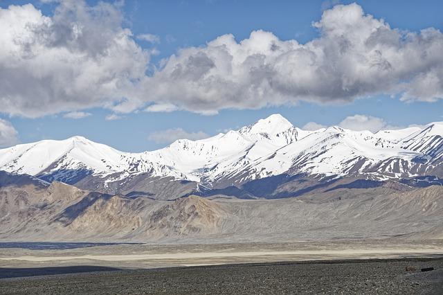
Pamir Plateau, Qinghai Tibet Plateau, and Yunnan Guizhou Plateau are the highest plateaus in the world, with an average altitude of more than 13000 feet. The plateaus with the highest average altitude in the world are Pamir Plateau, Qinghai Tibet Plateau, Bolivia plateau, Ecuador plateau, Yunnan Guizhou Plateau, Ethiopia plateau, Greenland ice, and snow plateau, Mexico plateau, Armenia plateau, Inner Mongolia Plateau, etc. Plateau is a vast plateau, flat or undulating land. Pamir Plateau is the highest altitude and largest plateau in the world. It is located on the border of Tajikistan, Kyrgyzstan, Afghanistan, and China. The highest point of the Pamir Plateau is qizilbagh volcano (6604 m).
The plateau is a flat land area with a height of at least 1000 meters. Pamir Plateau, Qinghai Tibet Plateau, and Yunnan Guizhou Plateau rank in the top three, with an average altitude of more than 13000 feet. There are many other plateaus in the world, such as Bolivia and Ecuador.
Next, let’s introduce the top ten plateau areas:
| order | name | introduce |
| 1 | the Pamirs | Pamir Plateau is a mountain range in Central Asia, where Tajikistan, Afghanistan, and China meet. It is the natural dividing line between Central Asia and South Asia. Pamir Plateau is about 1500 kilometers long from east to west and 800 kilometers long from north to south. Pamirs are home to many rare animals and plants. They are also home to some of the most isolated tribes on earth. Pamir Plateau is an area of high mountains and deep valleys. It is the home of many different ethnic groups, such as Tajiks, Kyrgyz, and Hazara. The Pamir Plateau is also home to some of the world’s highest peaks, including Mount IMON (7495m), mount ismoysomoni (7495m), and Mount Lenin (7134m). |
| 2 | Qinghai–Tibet Plateau | The Qinghai Tibet Plateau, an inland plateau in Asia, is the largest plateau in China and the highest altitude in the world, known as the “roof of the world” and “third pole”. It starts from the southern edge of the Himalayas in the south and ends at the northern edge of the Kunlun Mountains, the Arkin mountains, and the Qilian Mountains in the north. In the west, it is the Pamir Plateau and the Karakoram mountains. In the East and northeast, it is connected with the western section of the Qinling Mountains and the Loess Plateau, between 26 ° 00 ′ – 39 ° 47 ′ N and 73 ° 19 ′ – 104 ° 47 ′ E. |
| 3 | Bolivia Plateau | Bolivia is located in South America, with an average altitude of 3800 meters and an area of 350000 square kilometers. The middle part is a valley area with developed agriculture, and many big cities are concentrated here. The northern plateau is fertile and densely populated; The south is a dry desert area, sparsely populated, and only a few small towns are scattered due to mining. Lake Titicaca (shared with Peru) on the plateau is the largest lake in South America. |
| 4 | Ecuador Plateau | Its height is second only to the Qinghai Tibet Plateau, Pamir Plateau, and Bolivia plateau. It ranks fourth in the world. It is covered with snow all year round, and the highest point is mount Chimborazo, with an altitude of 6310 meters, which is the farthest place from the center of the earth. |
| 5 | Yunnan Guizhou Plateau | The Yunnan Kweichow plateau is located southwest of China. It is one of the four significant plateaus in China. It is situated roughly between 100 ° to 111 ° east longitude and 22 ° to 30 ° north latitude. It starts from Hengduan Mountain and Ailao Mountain in the west, Wuling Mountain and Xuefeng mountain in the East, Yuechengling mountain in the southeast, Dalou mountain on the South Bank of the Yangtze River in the north, and the mountains on the border between Guangxi and Yunnan in the south. It is about 1000 kilometers long from east to west, 400 to 800 kilometers wide from south to north, with a total area of about 500000 square kilometers. |
| 6 | Abyssinian Plateau | The Ethiopian plateau, also known as the Abyssinia plateau, is located in Ethiopia, East Africa. It is a wavy plateau with an average altitude of 2500 ~ 3000 meters and covered with vast basalt on ancient strata. Volcanic peaks with an altitude of more than 4000 meters stand on the plateau, which is very magnificent. It is the highest place in Africa and is known as the “roof” of Africa. With an area of more than 800000 square kilometers, it is an important agricultural area in Africa and the origin of coffee in the world. It also specializes in moss bran, Nuge (oil chrysanthemum), kudzu, etc. |
| 7 | Greenland ice and snow plateau | Greenland ice and snow plateau is located in North America, with an average altitude of 1900 meters and an area of 1.87 million square kilometers. Greenland’s most remarkable geomorphic feature is its vast and thick ice sheet, which is second only to Antarctica in size. Its average thickness is 1500 meters, the thickest part is about 3000 meters, and its area is 1.813 million square kilometers, accounting for 83.7% of the total area of Greenland. |
| 8 | Altiplanicie Mexicana | A plateau in the south of the North American continent in the middle of Mexico. The Mexican plateau accounts for 5/6 of the national area. It starts from the border between Mexico and the United States in the north and is surrounded by the Madre mountains in the East, West, and south, covering an area of 1.2 million square kilometers. The outer side of the mountains on the edge of the plateau is steep, and the inner side is gentle and broad, which makes the plateau uplift on the coastal plains on both sides like a square table in geomorphic form, so it is called “mesa” (meaning table plateau). The terrain of Mexico is mainly mountains and plateaus, collectively known as the Mexican plateau, so Mexico is also known as the “country of plateaus”. |
| 9 | ArmenianHighland | Armenianhighland is a volcanic lava Plateau located in Western Asia. Across Turkey, Iran, Armenia, and other countries. It is mainly composed of the elbows mountains, Zagros Mountains, Toros mountains, and pontine mountains, so it is also called the Armenian mountain knot, with an altitude of 4000 ~ 5000 meters and an area of 400000 square kilometers. Magmatic activity is intense, with many volcanoes, earthquakes, hot springs, and geysers. Many rivers are developed due to melting snow in high mountains, and large and small lakes are often formed in fault basins. Larger rivers include the Karasu River, Murat River, ARAS River, etc. The river valley is crossed by international traffic lines. |
| 10 | Inner Mongolian Plateau | The Inner Mongolia Plateau is the second largest of the four plateaus in China. It is part of the Mongolian Plateau, also known as the northern plateau. In a narrow sense, the Inner Mongolia Plateau is located in the north of the Yinshan Mountains, west of the Great Hinggan Mountains, north of the national border, and West to near 106 ° east longitude. It is between 40 ° 20 ′~ 50 ° 50 ′ N and 106 ° ~ 121 ° 40 ′ E. The area is about 340000 square kilometers. In a broad sense, Inner Mongolia Plateau also includes the Ordos Plateau to the south of Yinshan Mountain and the Alexa Plateau to the west of Helen Mountain, with an area of about 700000 square kilometers. |


